Search results
1 day ago · NOAA predicts above-normal 2024 Atlantic hurricane season. NHC New Products and Services for the 2024 Hurricane Season. Central Pacific. Eastern Pacific.
Latest Satellite Imagery. Satellite | Radar | Aircraft Recon | GIS Data | Analysis Tools. Unless otherwise noted, the images linked from this page are located on servers at the Satellite Products and Services Division (SPSD) of the National Environmental Satellite, Data, and Information Service (NESDIS). Please direct all questions and comments ...
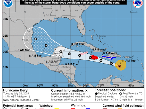
Satellite | Buoys | Grids | Storm Archive. ...EXTREMELY DANGEROUS CATEGORY 4 BERYL CLOSING IN ON THE WINDWARD ISLANDS... ... LIFE-THREATENING WINDS AND STORM SURGE EXPECTED THERE BEGINNING EARLY MONDAY MORNING... 8:00 PM AST Sun Jun 30. Location: 11.2°N 57.3°W.
Atlantic - Caribbean Sea - Gulf of Mexico. ...TROPICAL STORM WARNING EXTENDED NORTHWARD ALONG THE TEXAS COAST... ... HEAVY RAINFALL, COASTAL FLOODING, AND GUSTY WINDS EXPECTED ALONG THE COASTS OF TEXAS AND NORTHEASTERN MEXICO THROUGH THURSDAY...
1 day ago · National Hurricane Center. Top News of the Day... view past news. Last update Mon, 1 Jul 2024 02:47:56 UTC. NHC issuing advisories for the Atlantic on Hurricane Beryl and TD Three. Marine warnings are in effect for the Gulf of Mexico and Caribbean/SW Atlantic.
The National Hurricane Center is issuing advisories on Hurricane Beryl, nearing the Windward Islands and recently upgraded Tropical Storm Chris, located inland over eastern Mexico.
Current Hurricane Conditions. Weather Warnings - These bulletins (when issued) can be viewed by clicking on a colour filled region of interest on the weather information (alerts layer) map. Hurricane Track Information - Online map of the storms tracked by the Canadian Hurricane Centre.
Mar 14, 2022 · The National Hurricane Center and Central Pacific Hurricane Center's Tropical Cyclone Reports (TCRs) contain information on all tropical (and subtropical) cyclones that have occurred within the Atlantic, eastern Pacific, and central Pacific basins, including synoptic history, meteorological statistics, casualties and damages, and the post ...
3 days ago · National Hurricane Center, National Centers for Environmental Prediction, National Weather Service, National Oceanic and Atmospheric Administration, Department of Commerce. Disclaimer
The live hurricane tracker allows users to see the paths of previous hurricanes on this season’s hurricane map, as well as interact with the current hurricane tracker satellite imagery while accessing National Hurricane Center data and information.


