Search results
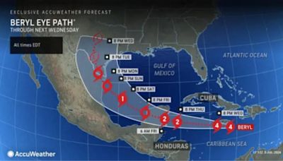
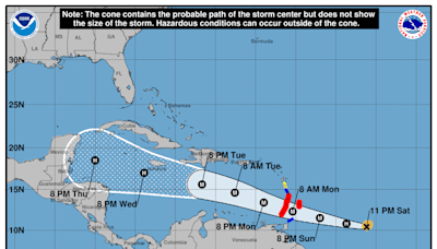
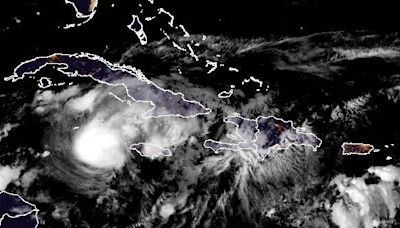
2 days ago · Satellite | Buoys | Grids | Storm Archive. ...CORE OF DANGEROUS HURRICANE BERYL EXPECTED TO IMPACT JAMAICA MIDDAY BRINGING LIFE-THREATENING WINDS AND STORM SURGE... ... EXPECTED TO APPROACH THE CAYMAN ISLANDS TONIGHT INTO THURSDAY... 5:00 AM EDT Wed Jul 3. Location: 16.6°N 74.4°W.
4 days ago · Hurricane Beryl Update Statement. THE SOUTHERN WINDWARD ISLANDS... storm surge to the Grenadine Islands, Carriacou Island, and Grenada. This is an extremely dangerous and life-threatening situation. the passage of these life-threatening conditions. wind speed of 92 mph (148 km/h) and a gust of 121 mph (194 km/h).
The live hurricane tracker allows users to see the paths of previous hurricanes on this season’s hurricane map, as well as interact with the current hurricane tracker satellite imagery while accessing National Hurricane Center data and information.
2 days ago · Hurricane Beryl upgraded to a "potentially catastrophic" Category 5 storm late Monday night, the National Hurricane Center said, as it crossed islands in the southeastern Caribbean. Beryl’s ...
The National Hurricane Center (NHC) is the division of the United States' NOAA/National Weather Service responsible for tracking and predicting tropical weather systems between the Prime Meridian and the 140th meridian west poleward to the 30th parallel north in the northeast Pacific Ocean and the 31st parallel north in the northern Atlantic Ocean.
The National Hurricane Center (NHC) mission is to save lives, mitigate property loss, and improve economic efficiency by issuing the best watches, warnings, forecasts and analyses of...
Jul 13, 2023 · NOAA’s National Hurricane Center — a division of the National Weather Service — has a new model to help produce hurricane forecasts this season. The Hurricane Analysis and Forecast System (HAFS) was put into operations on June 27 and will run alongside existing models for the 2023 season before replacing them as NOAA&r.
Sep 8, 2023 · Forecast/Advisories are issued on all Atlantic and eastern Pacific tropical and subtropical cyclones every six hours at 0300 , 0900 , 1500, and 2100 UTC ( learn about UTC time ). Special Forecast/Advisories may be issued at any time due to significant changes in warnings or the cyclone.
The Live Hurricane Tracker allows users to see the current tropical activity and interact with NOAA satellite imagery while accessing National Hurricane Center data and information.
4 days ago · As of the NHC's 5 p.m. update , Hurricane Beryl was located 250 miles southeast of Barbados and 350 miles east-southeast of St. Vincent. Beryl is moving toward the west-southwest at 18 mph. A ...

