Search results
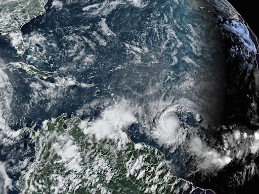
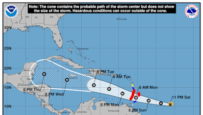
1 day ago · Satellite | Buoys | Grids | Storm Archive. ...DEPRESSION STRENGTHENS INTO TROPICAL STORM BERYL... ... EXPECTED TO STRENGTHEN INTO A HURRICANE AS IT APPROACHES THE WINDWARD ISLANDS... 11:00 PM AST Fri Jun 28. Location: 9.3°N 43.6°W. Moving: W at 18 mph. Min pressure: 1006 mb. Max sustained: 40 mph.
19 hours ago · National Hurricane Center. Top News of the Day... view past news. Last update Sun, 30 Jun 2024 01:09:11 UTC. NHC issuing advisories for the Atlantic on Hurricane Beryl. Marine warnings are in effect for the Caribbean/SW Atlantic.
The live hurricane tracker allows users to see the paths of previous hurricanes on this season’s hurricane map, as well as interact with the current hurricane tracker satellite imagery while accessing National Hurricane Center data and information.
6 hours ago · Hurricane Beryl has been upgraded to a "very dangerous" Category 3 as it approaches the southeast Caribbean, the U.S. the National Hurricane Center said Sunday. The hurricane is located about 675 ...
2 days ago · EXPECTED TO BECOME A HURRICANE BEFORE IT REACHES THE WINDWARD ISLANDS... 8:00 AM AST Sat Jun 29. Location: 9.8°N 46.8°W. Moving: W at 21 mph. Min pressure: 999 mb. Max sustained: 60 mph. Public.
The National Hurricane Center (NHC) is the division of the United States' NOAA/National Weather Service responsible for tracking and predicting tropical weather systems between the Prime Meridian and the 140th meridian west poleward to the 30th parallel north in the northeast Pacific Ocean and the 31st parallel north in the northern Atlantic Ocean.
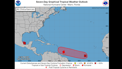
Tropical Weather Outlook. NWS National Hurricane Center Miami FL. 800 PM EDT Fri Jun 28 2024. For the North Atlantic...Caribbean Sea and the Gulf of Mexico: Active Systems: The National Hurricane Center is issuing advisories on newly formed. Tropical Depression Two, located over the central tropical Atlantic. Ocean.
The National Hurricane Center (NHC) mission is to save lives, mitigate property loss, and improve economic efficiency by issuing the best watches, warnings, forecasts and analyses of...
Current Hurricane Conditions. Weather Warnings - These bulletins (when issued) can be viewed by clicking on a colour filled region of interest on the weather information (alerts layer) map. Hurricane Track Information - Online map of the storms tracked by the Canadian Hurricane Centre.
Jul 13, 2023 · NOAA’s National Hurricane Center — a division of the National Weather Service — has a new model to help produce hurricane forecasts this season.


